Great War maps
Expected accuracy.
If you obtain a latitude & longitude point for a modern GPS and
apply that to a Great War map, can you be assured that when you visit
that point where Grandpa fought that it is exactly the right place?
The right place? Yes
Exactly? Only within limits.
The problems to overcome.
1. Are all the points shown on the map depicted to the same level of
accuracy?
No.
A church spire may well be more accurately placed than a junction in
a farm track.
Ignoring modern map making techniques based on GPS etc., in the Great
War era maps were made using a long and arduous process. The first stage
is to set out a chain of triangulation points to a very high order of
accuracy. In the UK some of these points are still visible as the familiar
Trig Points. These are called 1st order points. From these a larger number
of 2nd order points are triangulated, they are usually visible from a
long way off so church spires, towers and large buildings with flag poles
were favoured. From these teams of surveyors would set out 3rd, 4th and
5th order points giving positions of points of lesser importance on what
now looks more like a map rather than a set of triangles. Several techniques
are useful, even the one used by the Romans, Plane Table surveying. Once
this is complete the line detail is added, all the complex twists and
turns of roads and rivers and positions of more common buildings. The
problem with accuracy is that as points are created from a higher order
point, each time a lower order point is created it cannot be as accurate
as the higher order point, every measurement adds an error. Great effort
is made to minimise these errors but they will always remain, even on
modern maps.
The British Army had gone to war in 1914 with inadequate maps so a resurvey
had to be carried out as an emergency. This was therefore to less than
desirable accuracy.
On this link is an example of how a map
can be built from a few fixed points.
The Report on Survey on the Western Front 1914-1918 by Col. Jack said
this:-
Accuracy of Maps Dependent on Class of Survey.
The ideal in the map is an accuracy which a scale of 1/20,000 will not
conclusively show. 20 metres on the ground is 1 millimetre on this scale;
and 1 millimetre is a dimension so small as to be dangerously near the
possible error of contraction and expansion of the paper. Let us, however,
suppose as a working hypothesis that the position of every topographical
feature is known to an assured absolute accuracy of 20 metres, and let
us examine fully what this implies.
In the first place we can never be assured of absolute accuracy on any
point, no matter how well fixed. But we can speak of accuracy being
nearly absolute with reference to some point fixed in the centre of
the country-such a point as the Pantheon at Paris, for example.
Now in any general survey there must necessarily be a classification
of points into various orders, say, 1st, 2nd , 3rd , 4th and 5th . Suppose
the absolute accuracy, as above defined of the 1st order point is 1/1;
then that of the second order may be regarded as 1/2; of the third order,
1/4; of the fourth order, 1/8; and of the fifth order, 1/16. Now, though
this scale is arbitrary, a geometrical progression such as that given
does in practice fairly well indicate the manner in which the accuracy
falls off as the order increases. If we regard a 5th order point as
any ordinary topographic feature whatsoever, it is a fair assumption
that if the absolute error of that point is not to exceed 16 metres,
the absolute error of the 1st order point must not exceed 1 metre.
All points in a given area could of course be fixed approximately to
the same order of accuracy, even the highest. But in any other than
an extremely limited area the highest order could not be maintained
without rejecting the elementary principles of economy. Even in countries
with the highest development the economical factor necessitates the
introduction of the fifth order point, notwithstanding that in subsequent
warfare this fifth order point may assume a grave importance. If, however,
the assured "absolute" error of this point is to be less than,
say, 20 metres, a primary survey of the very highest class is unavoidable.
So an arbitrary point measured using latitude and longitude based on
the figures printed on the maps could be as much as 20 metres out of position
or it could be with a metre if it was a 1st order point.
The Report on Survey on the Western Front 1914-1918
2. Are maps from 1917 and 1918 more accurate than those from 1915?
Yes.
Early in the war some British 1:10,000 maps were redrawn from 1:80,000
maps. This means that any error on the original map would then be 8 times
greater on the new map. In 1915 a resurvey was started, the area around
Loos was finished just in time for the Battle of Loos in September 1915.
Other areas on the British front still had inaccurate maps.
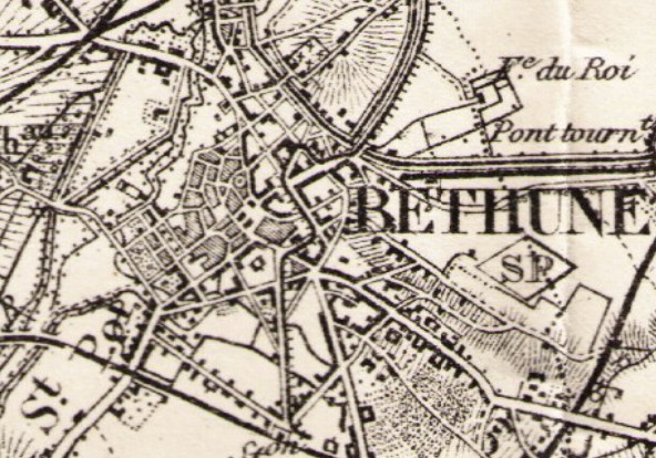
Inaccurate French 1:80,000 map from 1892 used as a source to re-draw
British maps.
3. Why is accuracy important in a Great War map?
Artillery.
If a map is required simply to show the respective positions of streets
and towns then an ordinary tourist map would suffice but artillery used
a technique called "shooting off the map". In this the guns
can be in a place hidden from view and hence they could not see their
target, a map was set up on a plane
table with a compass and the orientation and range to the target taken
directly off the map. A 1mm error in a 1:20,000 artillery map would give
a 20 metre error at the target in addition to other errors in shooting.
The army also required accurate maps to show the logistic situation, whether
a road could take one or two way traffic, carry heavy loads, be passable
in flood conditions etc. It also required accurate height information
so that it could be determined if a point was visible from another point.
4. Are trenches shown accurately?
Up to a point.
The first problem is that an accurate survey of the enemy trenches was
not possible so maps had to be created and updated from aerial photographs.
This is based on photogrammetry and comes within its own set of errors,
notably errors in the camera, whether it was pointed exactly vertical,
if the terrain below is hilly and quite a few more.
The second problem was to transcribe the trench lines onto the lithographic
plate used to print the maps. Various techniques were used including proportional
dividers but each contributes an error for every step in the process.
The final error was printing the maps, each colour was produced from
a different pass through the machine. Each pass had to be registered with
the base map. Viewing the corners of a trench map can show if this was
achieved, in quite a few cases it is several mm out. As 1mm on a 1:20,000
represented 20 metres, a 1mm registration error makes the whole trench
line 20 metres out.
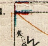
Map corner showing poor registration of colour runs. This is very common
on Great War maps and makes GPS positions of trench lines or other colour
printed feature less accurate.
5. Can the latitude and longitude figures printed on some of the map corners
be used in a GPS?
No.
It comes as surprise to many that a single point on earth can have dozens
of different latitude and longitude values, it all depends on where the
point is measured from, i.e. the datum. Most people will assume that the
Greenwich Observatory is zero degrees of longitude but that is not always
the case. Some older maps are based on the Pantheon in Paris or the Observatory
in Brussels so latitude and longitude values need to be converted. This
conversion is not a trivial problem and is itself prone to error. Part
of the problem comes from the use of a different "Figure of the Earth",
i.e. the values for the size of the earth, there are many to choose from
and different countries chose different values. An additional problem
is that sometimes which Figure of the Earth was chosen was not published,
it must be inferred. This means that some calculated GPS positions are
not as accurate as would be desirable.
GPS by default uses a datum (called WGS84) that does not accurately align
with the Greenwich meridian. If you go to Greenwich you will find you
need to stand about 109 metres East of the Greenwich meridian to make
your GPS longitude read zero.
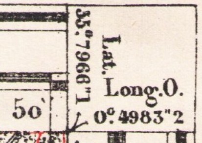
Latitude and Longitude shown at Great War map corner, here as Grades
not degrees
More information on this here:-
6. The British Army maps were based on yards, does this cause a problem?
Yes.
When the war started the best maps available were from Belgium, the surveyors
were not aware of the excellent French Plan Directeur 1:20,000 series
maps. To create a grid covering both France and Belgium, the Belgian maps
were set out on a large floor all joined together and the sheet lines
extended into France, hence the added letter in some sheets, sheet 51A
to the West of sheet 51. A problem arose from a misunderstanding, the
map makers assumed the artillery had to use yard based tables so they
superimposed a yard based grid on the metre based Belgian sheet lines.
That means that at sheet boundaries the yard based grid and metre based
sheet lines do not match. See here for how this
was done.
7. If all of the above were to be resolved and an accurate GPS point
established, can that be used to stand where grandpa stood?
Sometimes.
Whilst modern surveyor grade GPS can give an accuracy measured in cm,
phones with GPS and handheld consumer grade units give an accuracy of
approximately 5 metres, "most of the time". On one particular
occasion a GPS may be "spot on", on another it can be 20 metres
out. If it uses the Galileo satellite constellation, errors as high as
a kilometre can creep in because this constellation is not yet fully operational.
The problem is that a user may assume the unit is "accurate"
or worse, that the accuracy is constant. It is not. Measures of GPS accuracy
are statistical, i.e. described by probability. According
to the US Government, "GPS-enabled smartphones are typically
accurate to within a 4.9 m (16 ft.) radius under open sky" and
FAA approved single frequency GPS SPS receivers can achieve <= 1.891
metre (6.2 feet) accuracy 95% of the the time. This always gets worse
if not under an open sky, buildings, trees, especially those with wet
foliage, disrupt or attenuate GPS signals, reducing accuracy. The apparent
accuracy of car Satnavs is misleading, they use a technique that detects
the car is travelling along a particular road and then shifts the position
to centre the position on that road. In absolute terms, they are as accurate
as any other consumer grade GPS.
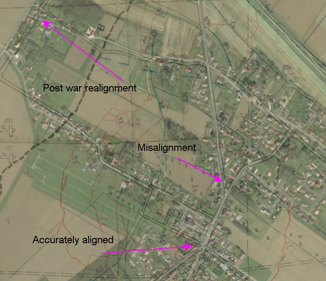
8. Can a calculated point be improved?
Yes.
The Report on Survey on the Western Front 1914-1918 by Col. Jack gave
the relative accuracy of a map as better than a third of the absolute
accuracy, so within about 6 metres. To get this into a GPS, a small map
fragment is positioned on a modern map and moved to make it fit. It will
be noticed that it fits where it touches, some (1st and 2nd order) points
will fit very well, others such as small roads and tracks may appear quite
in error for reasons stated here.
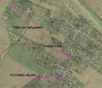
Map showing alignment and misalignment. Click for larger version.
9. Are all reported Great War map references accurate?
That depends on a number of factors.
A. Did the soldier have adequate fixed points from which to take bearings?
If in the artillery, they had access to accurate pickets used for gun-laying
so the reported grid reference is probably quite good. If in the middle
of a crater field such fixed points are harder to find. A soldier not
wishing to be the victim of a sniper may have rushed the plotting of a
point.
B. A grid reference where the Easting and Northing values are single digit
are only resolvable to 50 yards, i.e. the grid reference gives the point
at the South Corner of a 50x50 yard square. If the Easting and Northing
values are 2 digits east, this changes to a 5x5 yard square. Could the
solider at the time have determined his point within such a small square?
Conclusions
If you obtain a latitude & longitude point for a modern GPS and
apply that to a Great War map, can you be assured that when you visit
that point where Grandpa fought that it is exactly the right place?
The right place? Yes
Exactly? Only within limits.
Those limits could be as great at 50 metres or as little as 1 metre.
If precision is required, a GPS point should be correlated with other
means, e.g.
- Accurate compass bearings on the ground taken from fixed points. This
was often the means by which a soldier in the Great War would have fixed
their position and hence generated the grid reference of interest.
- Uses of a "transit" as in the practice of inshore sailors
who line up fixed points to take a bearing.
- Use of the relative position with other fixed points on the ground.
Then an intelligent calculation can be made on their relative merits.
A GPS is extremely useful, if used intelligently and with some circumspection.
|